


JMTS 012: All around the Globle
Supercharge your geo-literacy with these fun games & prompts. Plus how to make a DIY pinnable paper globe!

A number of years ago, I was working at the New York Times’ (now defunct) documentary television unit. I had been assigned to a project on the changing face of Christianity in the developing world, and we were considering possible filming locations. Someone said I should reach out to the Times correspondent in Ouagadougou.
I froze. Then, nodded. Convincingly, I hoped?
“Ouagadougou. Right. Of course. I’ll get right on it.”
The second I got back to my desk I pulled up a map in a panic. Ouagadougou? Where on Earth was Ouagadougou? I hadn’t a clue where to find it. Let alone how to spell it. Talk about imposter syndrome.
How did I get a job at the New York Times when I’d never even heard of Ouagadougou? How did I graduate from college? How could I even consider myself a citizen of the world?
Of course now I know (and will never forget) that Ouagadougou is the capital of Burkina Faso, in West Africa, population approximately 2.5 million. But it still makes me squirm with shame when I think about that episode.
I wish I could say that I proceeded to double down and learn the countries and capitals and features of Africa like the back of my hand. But the truth is…I’m still terrible at the geography of the continent. I’m equally abysmal identifying the Stans of Central Asia. Not to mention the countries in Oceania. Or North Macedonia. Or Armenia. I could go on.
There are 195 countries in the world recognized by the UN. My goal in 2024 is to learn them.
As complex world events unfold every day, it feels imperative to bust up my blind spots, and really get granular about what’s where in the world. Stitch together a deeper understanding of where countries are in relationship to one another.
Here’s a little pop quiz. Off the top of your head, can you name the seven countries that border Ukraine1? (See footnote.)
Being able to pinpoint a country on a map is one thing. Naming all the countries around it… that’s where the magic happens. That’s where the story unfolds.
Trade routes and transportation systems. Border disputes. Religious divides. Colonialism and imperialism. Migration and trafficking and freedom of movement.
Of course geography is about so much more than just where things are on a map. But being able to identify a country - say its name - is as good a place as any to start.
So…let’s have some fun with it!
Whether you share my goal to learn the who/what/where of all 195 UN recognized countries, or just want tickle your wanderlust, prep for a pub quiz, or feel generally better acquainted with the planet, here are some simple and engaging tools to level up your geo-literacy2:
Geography Locator Games
Globle (online only)
If you try one suggestion on this list, make it Globle. The objective of the game is simple: identify the mystery country. To start, guess a country at random. After each guess, the country is highlighted on the globe. The “hotter” (darker red) the color, the closer you are to the answer. Guess again to find out if you’re getting “warmer” or “cooler.” As you zone in on the mystery country, test your knowledge of a region, continually asking yourself what’s next to what. There’s no limit to the number of guesses. (It took me 20 tries to finally zero in on Micronesia!)

Worldle / Earthle (online and iOs/ Android app)
Love Wordle? Try Worldle! Each round of Worldle starts with the silhouette of the country you are trying to identify. After each guess, you will see the approximate distance and compass direction to the mystery country. (Unlike Globle, there is no contextual map.) For unlimited play, toggle the setting to “practice mode”. (Earthle is the app version of the basically the same game, from a different developer, with limited guesses.)
Geoguessr (online, Twitch. Subscription required.)
Image-based rather than map-based, Geoguessr ‘drops’ you along a road somewhere in the world and the objective is to deduce where you are. Use Google street view to scan the environment for clues — street signs, flags, language on shops or cars, architecture, landscape — then make your best guest and place a pin on the map within the 2 minute deadline. The closer you are to the actual coordinates, the higher your score. Choose between World, Famous Places, or Specific Country maps. Compete with friends and family in Multiplayer or Party mode.
Geography Quiz Games
Seterra (online and iOs/Android app)
Quiz your way to geography greatness with this robust educational game. Choose from more than 300 quizzes, organized by region or country, and locate the country/city/feature on a map. Drill down to discover quizzes of stunning specificity — Capitals of Oceania, African Countries South of the Equator, Governorates of Syria — or create your own Custom Quiz.
NY Times Geography Quizzes (online, free with NYT subscription)
Designed for teachers and students, these country-specific 5 question quizzes unlock more than just a country’s location. Multiple-choice questions fall under headings like History, Culture, Trade, Politics, Food, and draw from NYT reporting to provide context. Previously released once a week, new quizzes are now published monthly during the school year. To date, the archive includes 158 Country Quizzes (out of 195 UN recognized countries.)
International Cooking Night
During the pandemic, my husband and I embarked on a project we call International Night. We take turns picking a country, choosing the ‘national’ or representative dish, tracking down the necessary ingredients, and then we cook the meal together. To date, we have prepared a meal from 83 countries. For us, food is an ideal engine of discovery.
While we cook, we listen to music from the country. After dinner, we look up “fun facts,” or pull up the Wikipedia page for a quick crash course on the country’s history. We were so enamored by what we read about Oman, that the next year we actually went there. Further unlocking a wholly unfamiliar region, history, and culture.

When we contemplate the whole globe as one great dewdrop, striped and dotted with continents and islands, flying through space with other stars all singing and shining together as one, the whole universe appears as an infinite storm of beauty. - John Muir
Globes
Classic Globe
A classic terrestrial globe has an undeniable, timeless appeal. Use it as a reference tool, to inspire wanderlust, or to refresh your spatial perspective. (Oh, right! The world isn’t flat!) Beautiful, historical, replete with curiosities. Vintage Rand McNally Portrait Globes are all over Etsy. Use this handy chart to determine the age of your globe, then dig deeper into the story behind when/why a country changed names.
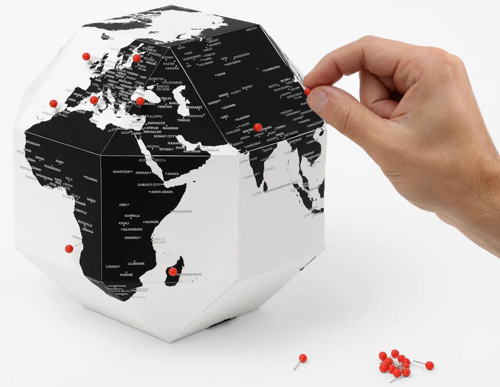
Pushpin Cardboard Globe
Cheaper than a traditional globe, fun to assemble, and interactive. Mark locations by puncturing the cardboard with a pin. Use it to say ‘I was here,’ like a vision board to mark where you’re headed, or to spotlight places you’re resolved to study up on. Dear World the Pinnable Globe is made in Italy by Palomar, and available from MOMA, Uncommon Goods and elsewhere. The New York Times offers a custom version (currently on sale!)
Better yet, see the prompt below for a DIY template to make one yourself!
Pushpin Cork Globe
These have a more globe-ish feeling than the cardboard ones because the shape is, well, globular. The function and fun are identical. Try using a pushpin to flag countries you’ve read about in the news, or that have women leaders, or places that are connected to your personal history. Find affordable options on Amazon or check out these fancy custom ones from Wendy Gold Studios.
Google Earth & Google Earth Pro Virtual Globe
Not to be confused with Google Maps, Google Earth is a geobrowser that uses satellite and aerial imagery, in addition to topographic and other data, to create the “world’s most detailed globe.” There are currently three versions available: Google Earth on web, Google Earth on mobile (iOs, Android), and Google Earth Pro on desktop. Zoom in on any location and explore using Street View, or click on the search field and push the ‘I’m Feeling Lucky’ button. It’s the digital equivalent of closing your eyes, spinning the globe, and then putting your finger down somewhere at random. You never know where you might land, or what you might discover.
Wall Maps
Wall Maps
You really can’t go wrong hanging a big map of the world on your wall, and referring to it on the regular. Or, if you’re a believer in ‘bigger is better,’ consider this really cool wall paper.
Flight Plans from Inflight Magazines
If you don’t have much wall space, the next time you fly somewhere, rip out the multi-page fold out international flight map from the complimentary inflight magazine. When my husband and I moved to Prague, Czechia for a few years, I taped it on the wall next to the kitchen table, and gazed at it every morning as I ate my breakfast…daydreaming our next adventure, learning about our new neighbors, marveling at how close different parts of the world feel when you make your home someplace new. (Keep an eye out for route maps from non-USA based airlines, with other countries at the center.) Flight plan maps are excellent for drawing on, annotating, using as a study tool, art project, or travel souvenir.
PROMPT: MAKE A DIY PINNABLE PAPER GLOBE
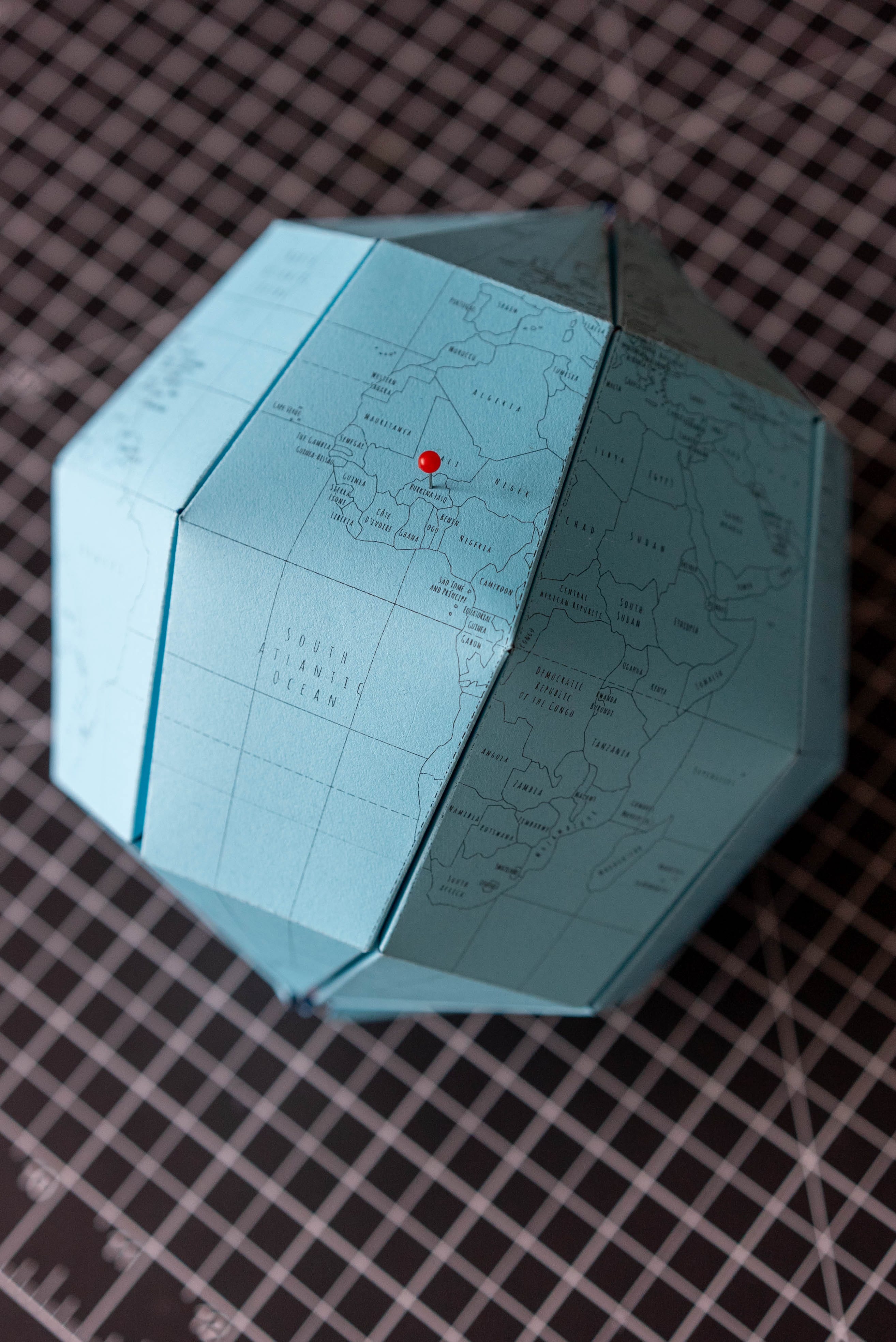
Le Paper Globe - a template for a simple do-it-yourself terrestrial globe - was created by French graphic designer Joachim Robert. Inspired by the Sectional Globe, earth’s axis, 23.4 degrees designed and created by Japanese company Geografia, Le Paper Globe (#lePaperGlobe) is available for free under a Creative Commons license. The downloadable template includes options to print on US Letter or A4 paper, with or without text. Download the file, then print, cut, fold, and assemble your very own globe!
Le Paper Globe designed by Joachim Robert (inspired by Geografia)
Materials Needed:
14 sheets of heavy duty paper (50 lb to 80 lb)
Exacto knife & cutting mat, or sharp scissors
Old ballpoint pen for scoring
Bone folder or straight edge
Printer (that will accommodate your chosen paper)
Optional:
Colored pencils, pens, markers, etc. to customize your globe
Pushpins
Instructions (link):
Download and print the template on US Letter/A4 heavy duty paper
Cut out the pieces using an Exacto knife or scissors
Crease folds with bone folder or ruler; or score the lines using ballpoint pen (on the back) and then fold
Fold the octagons along the dashed line, then cut out the inside pieces
Assemble the insides of the globe by fitting the folded octogons (pieces 7 to 14) into the pieces 5, 6a & 6b
Assemble the exterior pieces by fitting their side wings into the slits created by the folded octagons. Match 1a to 1b, etc. Repeat with all the pieces.
Customize and embellish your globe! Color in topography or flags, draw the route of the epic trip around the world you are planning, put pins in the countries of your ancestors, or follow your curiosity wherever it leads you!
Video (30 sec JMTS demo):
How’s your geo-literacy? How do you enjoy learning what’s where in the world? Who wants to join a GeoGuessr party? Let me know in the comments or reply to this email. I love hearing from you. Thanks for being here!
👋 O genki de ne,
Julia Morrison
Ukraine shares a border with these 7 countries: Romania, Moldova, Hungary, Slovakia, Poland, Belarus and Russia.
Geo-literacy is a term coined/adopted by National Geographic to mean proficiency in the interconnections between places and systems.
Loved this post. It reminded me of when I was interning as a copy editor and one of the articles that came across my desk was about something taking place in Georgia. However, by the contents of the story, it was obvious that this Georgia was NOT the state that we all know for its peaches. I was flummoxed -- I had never heard of a country called Georgia, and this was in the pre-Google days, so I couldn't look it up anywhere, and I was too embarrassed to ask anyone. I proceeded to change "Georgia" to "Ga." per AP Style, and the managing editor changed it all back later. He never mentioned it, probably to save me further embarrassment!